Geography
- Surface: 885 ha
Highest point : 110 m (Quatre Bras and Trois Couleurs)
Lowest : 44 m (Boulevard de la Woluwe) - Climate: the climate is fresh and humid with weak thermal variations. In Woluwe-Saint-Pierre, the annual average temperature is 10°C. The average temperature for January is at 2,2°C and for July at 17,8°C. Annual average precipitations for Brussels are 699 mm.
- Pedology: Woluwe-Saint-Pierre has a ground formed of sand, silt and clay.
- Natural vegetation: our municipality has 178 ha of public parks on a global surface of 885 ha. Some 8700 trees of alignment are also counted for a total of 106 km roadway systems. Among these spaces, there are the Parmentier park, the park Woluwe and the forest of Soignes.
- Rivers: we can count three rivers on the municipality, resulting from a ground water located in the basement: the Kersbeek, that flows into the Leybeek, and the Vloedgroebbe. As for the Woluwe, which crosses Woluwe-Saint-Pierre, it takes its source in Boitsfort. These rivers, except for the Woluwe, have nowadays almost disappeared from the landscape.
- Habitat: the municipality counts only two zones of masonries: an absolute residential zone which includes only isolated villas, or grouped by two or three, and of beautiful large luxurious houses; and a mixed zone which includes dwellings joined between gables and small industry or commercial firms. There are no agricultural zones anymore and it is out of the question to see emerging industrial parks.
- Routes: three regional roads, with much traffic, cross the municipality: the “avenue de Tervueren”, the boulevards “Brand Withlock” and “Saint-Michel” and the “boulevard du Souverain” and “boulevard de la Woluwe”. The roadway system currently includes 106 km, including 11 km of regional roadway systems.
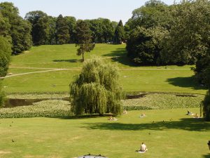
The park of Woluwe